![[Banner] 17th Karmapa during the blessing](./thm/new3/img/b2_v_mediach_h.jpg "17th Karmapa during the blessing")
Clarity of mind is nothing other than awareness aware of itself.
Lama Ole Nydahl
How to get to Mangútovo
Maps

Map of Slovakia
- link to Google maps

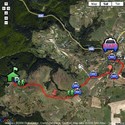
Detailed map
Nearest bigger cities from where you can get to Mangútovo
- Bratislava
- Vienna/Wien
- Budapest
By car
- from Bratislava take the route to Nitra, next Žiar nad Hronom, Zvolen, then straight to Lučenec, passing Detva, passing Kriváň and continue to Hriňová
- from Košice take the route to Rožňava, Rimavská Sobota, Lučenec, passing Kriváň and continue to Hriňová
- from Žilina take the route to Martin, Banská Bystrica, Zvolen, then straight to Lučenec, passing Detva, passing Kriváň and continue to Hriňová
Notice for the motorbike owners - it may be difficult to get to our land by normal motorbike, especially when the road is muddy.
Navigation for cars
Google navigation | Photo-navigation
By public transport
Check out the site www.cp.sk to see what busses and/or trains to take, to get from your location to Hriňová. The best route is to take a bus to Zvolen and there you change to a bus going to Hriňová (Get off at "Hriňová - stred" bus stop). Those, who dare can follow navigation for walk. If you need a shuttle from the bus station of from the parking at the Ski Center Košútka, call us.